Case study
High Ground for U.S. 101
A Bypass and Drainage Concept for Seaside, Oregon
Discussion draft, not submitted to ODOT.
U.S. 101 keeps flooding on low ground near Seaside, closing the coast's main through route. The Oregon Department of Transportation (ODOT) is conducting a $250,000 study of the problem between mileposts (MP) 22.5 and 25, with online comments open through Nov. 29, 2026. This case study uses public data to examine a longer-term alternative: moving the U.S. 101 through route out of town onto higher ground, while improving drainage on the local streets that remain on the valley floor.
Key findings
- The existing alignment sits on low, wet ground. Within 330 ft of U.S. 101 at MP 22.5 to 25, 67% of the land is in the Federal Emergency Management Agency (FEMA) 1% annual-chance flood zone, often called the 100-year floodplain, and 33% is mapped wetland.
- Closures recur. From 2002 to 2009, the road closed about 3.3 times a year for an average of 44 hours, forcing a detour of about 70 mi. It closed again in December 2023 and December 2025.
- The in-town route is almost entirely in the tsunami zone. Of the 4.3 mi of U.S. 101 from the U.S. 26 junction to Lewis and Clark Road, 99% lies within the largest Cascadia tsunami scenario (XXL1) mapped by the Oregon Department of Geology and Mineral Industries (DOGAMI).
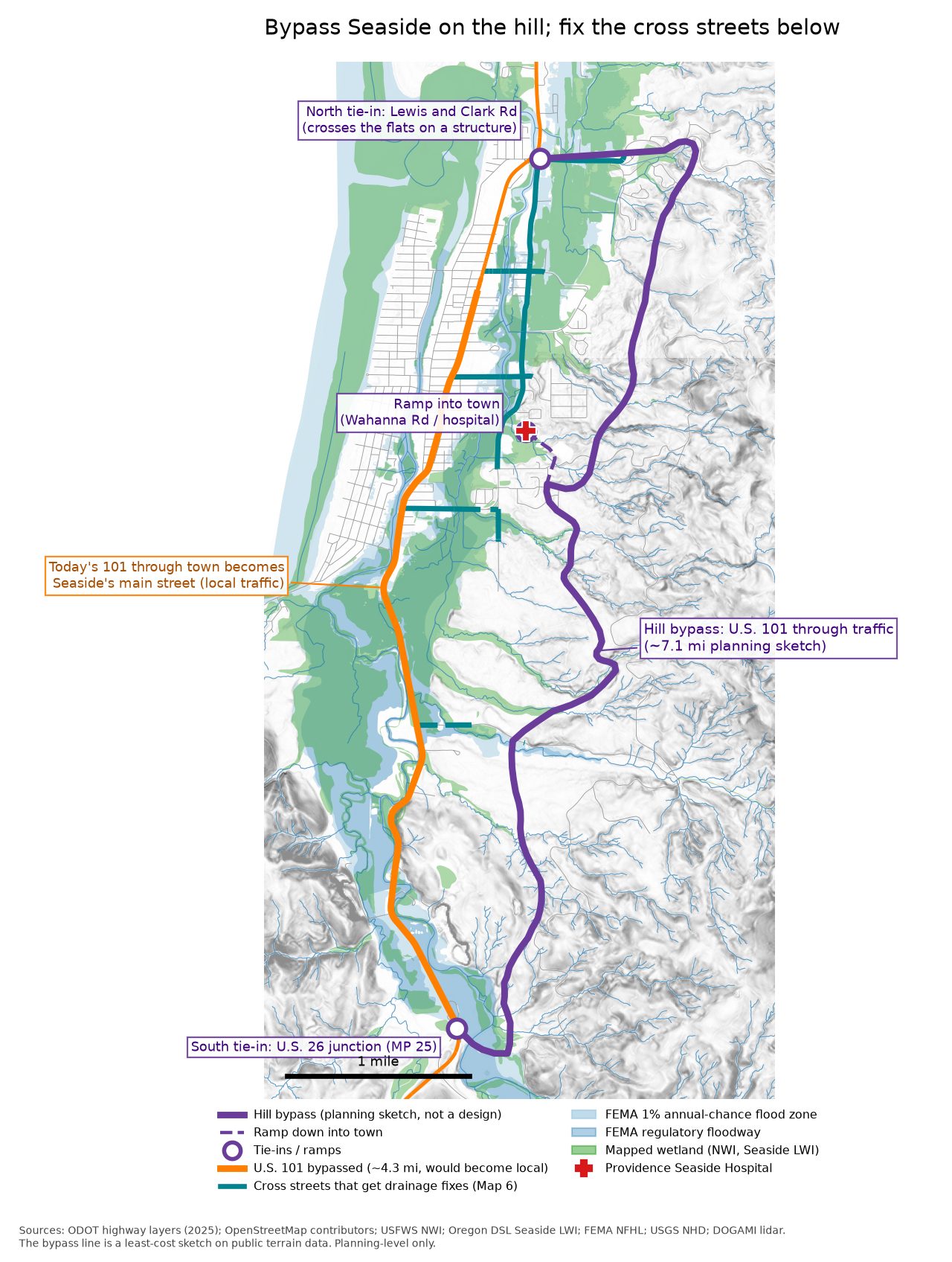
- A hillside bypass would avoid most flood and tsunami exposure but not landslide risk. A 7.1-mi planning sketch lies 89% outside the XXL1 zone, but 73% of it crosses ground DOGAMI rates "Very High" for landslide susceptibility.
- Cost alone does not settle the question. Over 50 years, the bypass would break even only if keeping U.S. 101 in town cost $4.9 to 37.7 million a year, depending on the discount rate and final cost. Traveler delay from closures is estimated at about $2 to 6 million a year, and ODOT does not publish maintenance costs for this segment.
The three-part concept
-
Near term: keep U.S. 101 dry
Raise the roadway or build a trestle at MP 22.5 to 25 using ODOT's raised-roadway or trestle option, designed for projected 2100 sea levels.
-
Long term: a hillside bypass
Carry U.S. 101 through traffic east of town, with ramps into Seaside. The existing in-town route would become a local main street, transferred by agreement under Oregon law.
-
Cross-street drainage
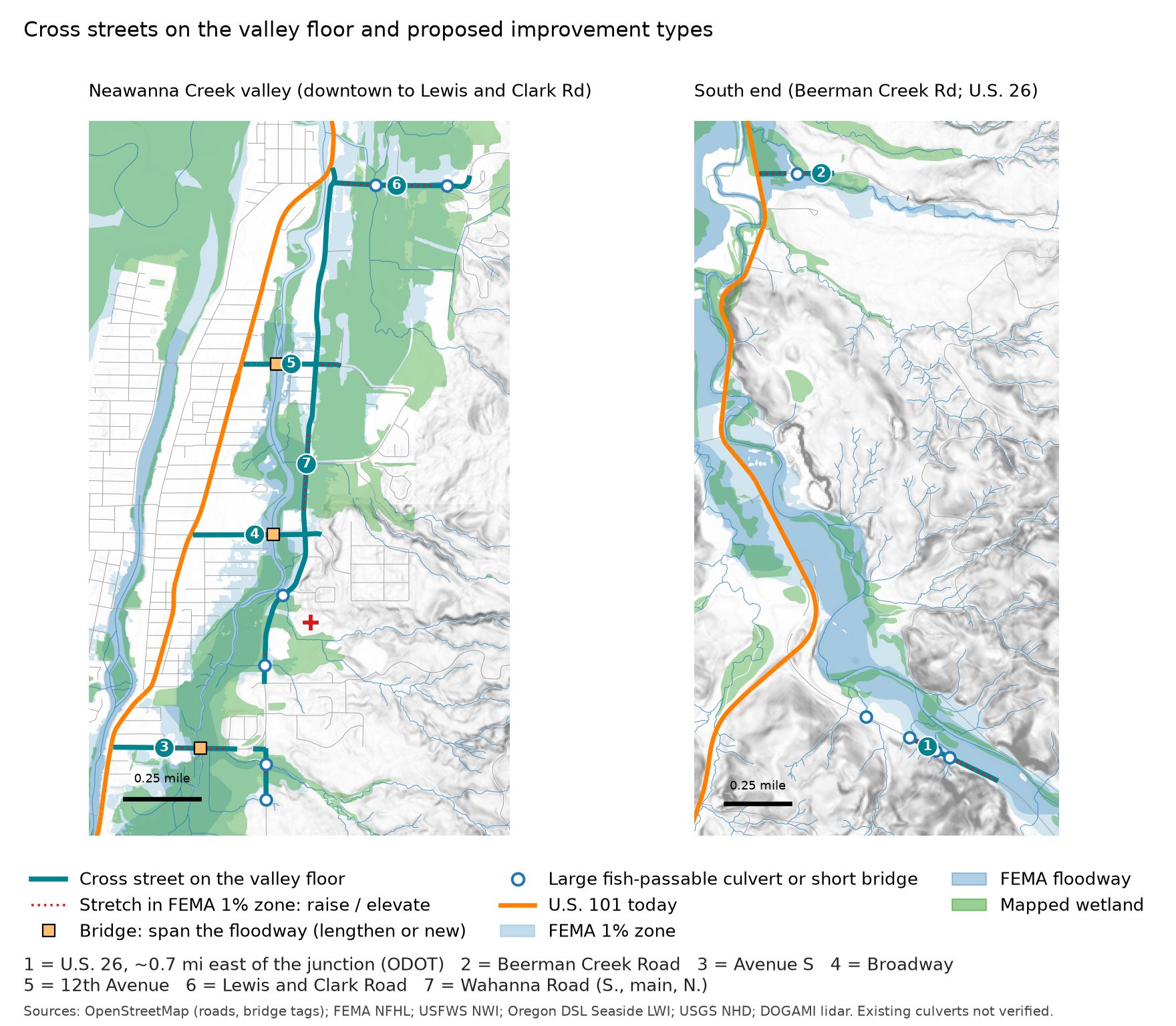
Build longer bridges, large fish-passable culverts and raised sections on seven east-west roads that cross the valley floor, including evacuation routes to high ground. Stream crossings come from mapped stream lines. Unnamed channels and ditches are kept as habitat: small channels and roadside or farm ditches are often important winter rearing habitat for juvenile coho and other salmon. Whether each unnamed line is a ditch or a natural channel is unverified, and every crossing needs a field check before its fish passage design is set. Existing culverts were not inspected.
Planning-level capital costs
| Element | Range (2024 $) |
|---|---|
| Part 1: raise or trestle at MP 22.5 to 25 | $7.7 to $14 million |
| Part 2: hillside bypass, 7.1 mi (excludes land, ramps, contingency) | $246 to $521 million |
| Part 3: local cross streets (priced elements only) | $31.2 to $52.2 million |
| Part 3: U.S. 26 crossings (priced elements only) | $13 to $71 million |
What we'd ask ODOT for
- Identify a hillside bypass corridor in the study's recommendations as a long-term option, and fund a corridor study that includes geotechnical investigation and an origin-destination traffic study to establish the share of through trips.
- Design the near-term fix for 2100 sea levels, using at least +2.26 ft at Astoria and testing against +5.48 ft, and select the option that avoids the most closures per dollar.
- Partner with Seaside and Clatsop County on cross-street drainage, beginning with the three existing Neawanna Creek bridges on Avenue S, Broadway and 12th Avenue, built longer and to current seismic standards. Add Wahanna Road, the likely back road to the hospital (unconfirmed). Address ODOT's own crossings on U.S. 26.
- Publish current costs for the segment: maintenance and emergency repair spending on U.S. 101 through Seaside, closure dates and durations, and cost estimates for Options 1 to 4.
- Compare 50-year life-cycle costs for the existing alignment, the near-term fix alone, and a bypass with jurisdictional transfer of the existing route, stating the discount rate used.
- Report whether the segment is identified under 23 CFR Part 667 as a facility repeatedly requiring repair after emergency events.
- Begin early consultation with the Clatsop-Nehalem Confederated Tribes, timber landowners, the City of Seaside, Clatsop County and state and federal fish and wetland agencies on corridor protection and transfer terms.
Limits
This document presents a planning sketch, not an engineering design. All costs are planning-level estimates derived from published benchmarks, and none is an engineering estimate or bid. The bypass is a long-range concept with high cost and significant geotechnical risk, as 73% of the sketch crosses ground rated very high for landslide susceptibility. The near-term fix and the cross-street improvements are worthwhile whether or not a bypass is pursued.
Ranked with CERP
Coming in a later update.